
Rudolf puts on his hiking boots and his warm clothes to hike and photograph this trail long through rain, snow and sunshine, he searches for photo opportunities to complete the experience. Follow his journey and the photos he captured.
It’s still dark when I get off the bus and begin hiking up the narrow, winding lane, which leads up into the mountains on one side of the Upper Sava Valley in Slovenia. The blanket of snow gradually increases in depth as I climb higher, there’s a click-clicking of hiking poles as they strike the asphalt, and my breath forms pale clouds in the beam of my head torch. I can’t feel the cold through my clothes yet, but I know that later when I stop moving, I will.
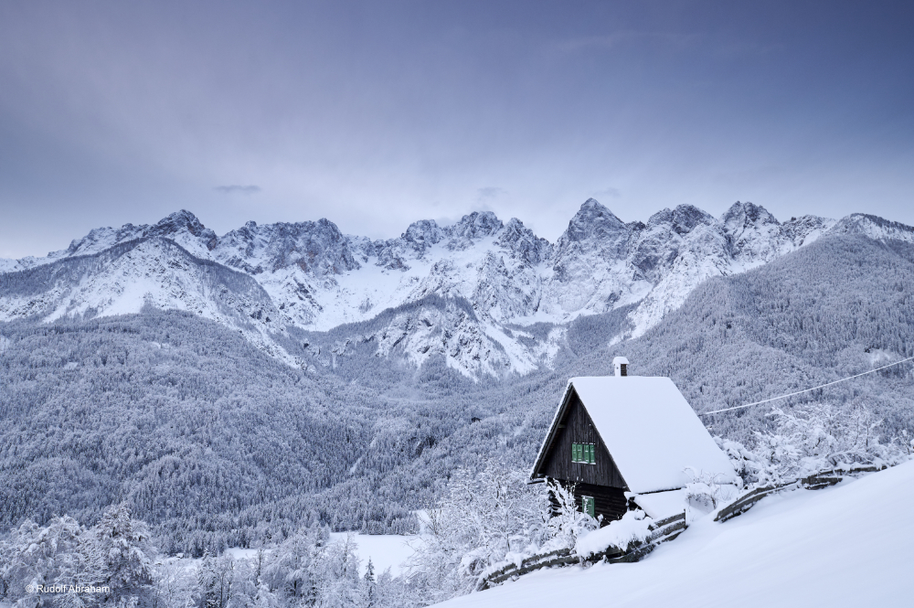
Early morning light at Srednji vrh, near Kranjska Gora, after snowfall in late November, with a view across to the Martuljek mountain group.
It’s the end of November, and the previous day and night have seen the first heavy dump of snowfall of the winter. Perfect timing, in my case. I’m heading for a place called Srednji vrh, an open meadow beside a few cottages, which commands a gob-smackingly good view of the Martuljek group – a broad amphitheatre of pointy peaks across the other side of the valley, which form the northeastern outpost of the Julian Alps. I’ve visited Srednji vrh several times over the years, hiking one trail or another – in this case, it’s the Juliana Trail. However the peaks across the valley only really get the sun first thing in the morning – hence the very early start.


Zelenci Nature Reserve after late November snowfall; Lone figure at sunset on the ruins of St Valentine’s Church, on the Sabotin ridge.
The Juliana Trail is a 330km long-distance hiking trail through Slovenia’s Julian Alps, consisting of a 270km circuit of the country’s highest mountain, 2,864m Mt Triglav, plus a 60km linear route branching off the main circuit to the south. It never climbs the famed Triglav, despite the fact that this mountain lies at the centre of Slovenia’s most popular hiking area – and that, according to popular opinion, it’s a peak that every true Slovene should climb at least once in their lives. But that’s the whole point. The Juliana was conceived as a way to divert footsteps from the increasingly crowded trails on Triglav, and encourage visitors to explore the surrounding area instead – much of which, with the exception of a small handful of places like Bled and Lake Bohinj, gets largely overlooked in the quest for bagging Slovenia’s highest summit and then leaving after only two or three days. There’s so much to explore in the surrounding area of Triglav National Park and beyond, from passes and gorges to wetlands and forest, plus a ton of other stuff from this region’s long and rich history, from hilltop churches filled with 16th century frescoes, to WW1 heritage, and a legacy of mining and ironworking stretching back to the Romans.
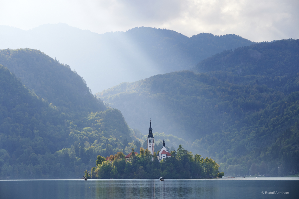
Island and church on Lake Bled.
It takes me around an hour following the road, before I turn left through a farm gate, wading through knee-deep snow by this point and avoiding the larger drifts which disguise the uneven slopes on my left. Still dark, good. Everything is incredibly still. I set up my tripod, clamp the ball-head to my camera’s L-plate, screw a filter holder onto the front of the lens, and compose the shot using the rear screen. This part’s easy, I know the place already, so I don’t have to search around in the dark. Then I wait, as the snow around me begins to lighten imperceptibly, and the numbing cold begins to seep into my boots.
I first hiked parts of what would later become the Juliana Trail around 25 years ago, when I was living just over the border in Zagreb, Croatia – from where the Slovenian capital Ljubljana was not much more than a two hour train journey away, and the Julian Alps were perhaps the ultimate diversion from my days working as an English teacher. Later I hiked other sections which happened to overlap with the Alpe Adria Trail, which I was writing a book on – and then walked and re-walked the entire trail after it was launched, while writing the first guidebook to the new Juliana Trail. The pandemic intervened of course – the trail was launched at the end of 2019, and I had a contract for the book just a few weeks later, but it was the autumn of 2021 when I went back to hike the Juliana. It was my first long ‘proper’ hiking trip since the pre-covid era, a factor which made the prospect of setting off on this trip almost insanely exciting.
I hiked the main, 270km circuit in around 12 days, instead of the usual 14, during late September and October – and returned about six weeks later to revisit some spots again for more photos, and to hike the 60km extension which heads down through the mountains on the west side of the Soča Valley, against the border with Italy. I’d hoped the second trip would coincide with the first snowfall, and it did.


Autumn crocuses on the trail down from the Pokljuka plateau to Lake Bohinj; Rocky trail on the Sabotin ridge, with the Soča Valley below; In the mountains along the west side of the Soča Valley, looking into Italy.
After about an hour at Srednji vrh I packed down my tripod, and hiked back down towards the town of Kranjska Gora on the trail through the forest – I’d only taken the road on the way up because it would be more straightforward in the dark. The light was still dim among the trees, the trail more or less invisible, and branches hung low across the path, weighted down with snow. It took me almost twice as long as it usually would to reach the valley floor, by which time I was covered in snow – and had just enough time to grab some breakfast, then my pack, before heading off on another snowbound route along the valley floor.
In terms of gear, I approached the Juliana much as I would any other long-distance trail – stripping down weight as much as I could, but still carrying enough to cope with fickle mountain weather (in September/October, this went from hot sunny days to frosty mornings and then several days of rain). Camera-wise I took a Nikon mirrorless body, with just three lenses – a 24mm tilt-shift which doubled as my main landscape lens while also covering times when I needed to photograph architecture along the way; a 70-300mm variable zoom for pretty much everything else; and a fast 50mm for the occasional portrait (which I think, from memory, mostly stayed in the bag). There are some exquisite waterfalls along the Juliana, for which reason there was no way I was doing this walk without carrying a tripod. When I returned at the end of November, I needed to add winter trousers, gaiters, winter gloves and some extra layers.
I started the main loop in the north, and spent the first few days hiking along and above the Sava Valley then south past iconic Lake Bled and up over the sprawling Pokljuka plateau, before descending to Lake Bohinj. I added in a few side trips along the way – to the Vintgar Gorge near Bled and the Tolmin Gorges just outside Tolmin, the Savica falls near Lake Bohinj, the Upper and Lower Peričnik falls near Mojstrana, and the Kozjak falls near Kobarid, among others. These are all easy to get to, and only the Savica falls required a bit of a race to get there at the end of a day’s hike, before I lost the light – the falls and the emerald-coloured pool into which they plunge are enclosed by steep cliffs. I walked fast along the northern shore of Lake Bohinj, stopping only to get some shots at the far end of the lake, of the surrounding mountains silhouetted against the evening lights, then hiking even faster up a gravel road followed by a stepped forest trail up to the falls, arriving with just enough time to get some images, before returning much more slowly in the dark.


Savica falls; Looking down into one of the Tolmin Gorges; Zelenci Nature Reserve in autumn.
I was about eight days into the main loop of the Juliana – halfway down Baška Grapa, a little-visited valley in the southern part of the Julian Alps, and on a relentlessly steep hillside, to be precise – when the weather weather took an apparent disliking to me, and set in for three or four days of pretty much non-stop rain. Hiking in a downpour is one thing; trying to capture a decent landscape image (not to mention taking notes, which I’d actually need to be able to read later while writing a guidebook), quite another. Using a wide lens becomes disproportionately more difficult (obviously because of the shallower lens hood, rain gets on the front element almost immediately), and trying to use a graduated ND filter is just a waste of time. In one area of forest, I saw more salamanders than I’ve ever seen in one place, but there was so little light, despite it being early afternoon, that I found it hard to get even one decent image using the slow, variable focus zoom I was carrying, and everything was simply too wet at that point to contemplate changing lenses. Rain covers or not, I find that over a long day hiking in the rain, camera bags and their contents inevitably get wet and stay that way until the evening, and along with clothing and backpack and boots there’s often only so much of it I can get dry overnight. (I use dry-bags inside my pack to prevent spare clothing and essentials getting wet – Osprey make some good ones – and ziplock bags for spare cards and batteries inside my camera bag for the same reason.)
But what it gave in terms of washed out photography days, the weather more than made up for in sheer spectacle. Waterfalls became enormous – including the Boka falls, the highest in Slovenia, which spurts out of a cliff-face before free-falling some 70m. And on the climb up towards the Predil Pass, a gorgeous route which takes in a succession of beautiful, remote waterfalls and rock pools, there were falls where none should exist, plunging down cliff faces which framed sweeping views of snow-dusted peaks.
One of my favourite spots along the Juliana Trail is Zelenci Nature Reserve, a wetland area just west of Kranjska Gora, below the tripartite border of Slovenia, Austria and Italy. Zelenci is the source of the River Sava, which comes bubbling up from the bed of a shallow, vividly coloured pool surrounded by braided channels and reed beds. I’d passed this way in October, on the last day of hiking the main Juliana circuit (by which time the rain had stopped, and my boots were dry), when the landscape was still dressed in the rich golden browns of autumn – and I returned at the end of November, to photograph it streaked with fresh snow. I always feel it’s something of a privilege to be able revisit areas like this, to see and record them in different seasons, different lights.
Another highlight is the final part of the linear extension in the south, which follows the Sabotin ridge along the Slovenian-Italian border – a cliff path framed by jagged, sharp rocks and twisted bushes, with the Soča Valley plunging on your left. The bura – the infamous northeast wind which you’ll come to know if you spend any amount of time travelling in Slovenia or Croatia – was blowing in sudden, sweeping gusts. It was late in the afternoon, and the Soča Valley was sinking into deep shadow, like a rising pool of darkness, while the ridge on the far side stretched in a ripple of coppery gold in the autumn light, on either side of the silhouetted monastery of Sv Gora.


Descending through the forest towards Most na Soči; View of Sv Gora in evening light; Church and Italian Charnel House at Kobarid, at dusk. This monument contains the remains of over 7,000 Italian soldiers who died during the various battles along the Isonzo Front during WW1.
Like other stages before it along and above the Soča Valley, this part of the Juliana winds through the scattered remnants of WW1, when this area formed the front line between Austrian (Slovenia then being part of the Habsburg lands) and Italian troops. This was the Isonzo Front (Isonzo being the Italian name for the Soča), scene of a horrific series of battles, stagnation and freezing temperatures which left a million dead. It was also the setting Hemingway’s A Farewell to Arms, based on his experience as an ambulance driver here in WW1. By the time I reached the shell of the small church of St Valentine at the end of the ridge, the sun was sinking low and sending down fingers of light across the plains of Friuli below. And just as I got there, I saw a figure standing on the wall, partly silhouetted against the sun – and managed to grab a couple of frames before they moved.
If that was a lucky ‘grabbed’ shot, one of the more ‘planned’ was the Vintgar Gorge near Lake Bled – a slight detour from the Juliana itself, but one that most people hiking the trail would want to include. The thing is, this shot would have been difficult if not impossible to take under ‘normal’ circumstances. The gorge is extremely popular, and the boardwalks (the only path though the gorge) are narrow and tend to get very busy, and can only be walked in one direction. Under these circumstances, setting up a tripod would have been awkward and inconsiderate to say the least. As it happened, I went out of season when the gorge was officially closed, but was fortunate enough to get permission for it to be opened and go in with a guide – meaning that I had the place to myself, and plenty of time to walk the gorge in both directions, not to mention the most extraordinary late autumn light which further down the gorge turned patches of water to liquid gold.
Getting the desired amount of movement in the water – a little, but not so much that it all turns to sludge – was, as always, just a matter of trial and error. In this case I set the ISO to 200, and I shot this image at 1/5 seconds at f/11. I used a Gitzo Traveller Series 2 Traveller (I find this a good balance between stability and weight for hiking, with the centre column permanently removed) with an Acratech Ultimate Ball-Head, and a 24mm lens.
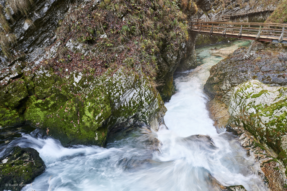
I took it on the return back through the gorge, having had the benefit of being able to scout out different possible locations – and, perhaps not surprisingly, this one was absolutely not the spot I’d envisioned. As well as showing some movement in the water (at this point in the gorge there are some rapids, and the river is narrow and running quite fast), I wanted as much water in the shot as possible (so I’m standing on a slight bend in the gorge), and I wanted to include the boardwalks crossing the river further downstream. I was lucky with the light – there were no patches of direct sunlight here at the bottom of the gorge, although it was hitting the upper parts of the slopes above, making for nice saturated colours. For me the lack of anyone else on the boardwalks further downstream, while this might not be what you’d generally see, adds to the sense of stillness combined with the rush of water.
Next adventure: Carnivals & festivals
Previous adventure: Two Feet, One Lens – Switzerland
All images © Rudolf Abraham
Photographer https://www.rudolfabraham.com
