
Firstly, the title: it almost never is just one lens, though the number of feet remains the same. The combination of hiking and photography – and more specifically, I’m talking here about multi-day hiking trips in the mountains which usually involve carrying a full pack with your own hiking gear, as well as camera gear – inevitably comes with a series of compromises.
The challenges of hiking with a camera – preparation
If you’re carrying a full pack, as opposed to just loading everything into the boot of a car and doing a short hike from a parking spot, you really do have to think very carefully about weight – how much gear can you carry comfortably (and preferably, enjoyably) for several days, over possibly difficult terrain? Equally, you have to reach a goal (be it a mountain hut, a guesthouse, even just somewhere level enough to pitch a tent) by somewhere around nightfall, preferably rather earlier. So while landscape photography is more often than not dictated by the light (and therefore, the time of day), time is not always something you have on your side on multi-day hiking trips – a particular setting which screams that you should really sit and wait for the golden hour to arrive, might well be several hours walk from the end of a stage. If you’re carrying a tent in order to avoid these restrictions, and are in an area where you can at least get away with pitching up a tent in the perfect spot to await the perfect light, you’ll also be carrying a sleeping bag, sleeping mat, food and a stove – so, more weight.
Of course, there are ways to balance all of this somewhat by choosing ultralight hiking kit – this is effectively what I do, to allow me to carry a little bit more in the way of photo gear; and there may be the option of baggage transfers, though not everywhere, or on every stage. But ultimately, unless you’re just taking photos on a phone, camera gear is not generally the definition of ultralight – whether we’re talking one lens, or three.


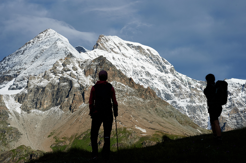
Evening view from Cabane de Chanrion – Wall of peaks east of Rifugio Champillon – Hiker above the Glacier de Corbassière – © Rudolf Abraham
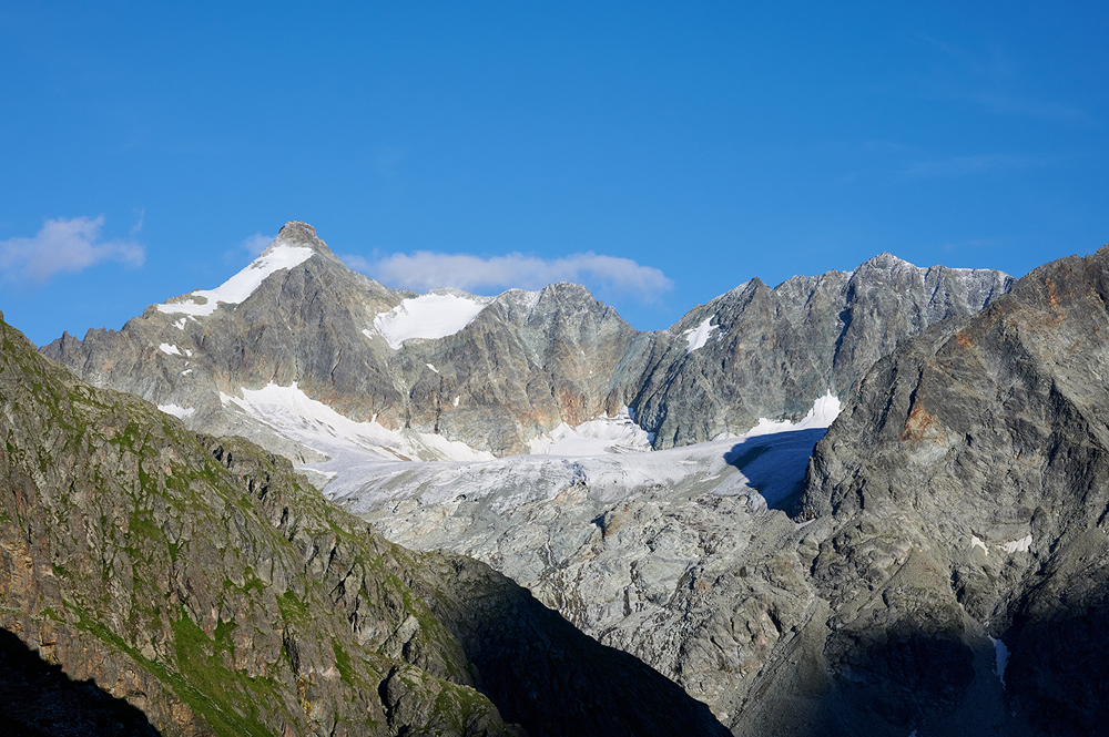
The Glacier de Corbassière spews down below the eastern flanks of the Petit Combin, terminating in a several storeys high wall of ice. From below it, a foaming, milky grey torrent gushes down the valley between boulders the size of industrial refrigerators, while further up the valley, the glacier’s fractured, steeply-pitched surface twists right, disappearing into low cloud. It’s a vast, awe-inspiring sight, one of the largest glaciers in the Swiss Alps – and yet it’s shrinking at such a rate that it may well have vanished by the end of the century. Standing at one end of the suspension bridge, which crosses the valley some distance downstream from the snout of the glacier, I’m looking with something like horror at two large rocks between me and the glacier, each with a date painted in large, blue letters.
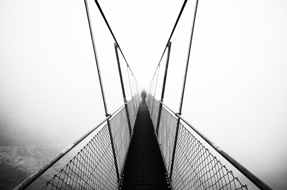
These give its position in 2020 and 2018 – in the latter year, the snout reached almost down to the suspension bridge, an almost mind-boggling volume of ice to have vanished in under five years (on average, Swiss glaciers have lost a shocking 10% of their volume in the past two years alone). However much you’re aware of glacial retreat, it doesn’t prepare you for the scale of the thing when you’re actually standing there looking at a loss of ice somewhere equivalent in size to a shopping centre. A bank of mist is rolling in, so I zip my camera into a holster, shoulder my pack, loop my poles around my wrists, and set off across the bridge, which sways slightly with my steps, turning to monochrome behind me before being swallowed by the void.
The views without the crowds
It’s towards the end of of July, and I’m hiking the Tour des Combins – a roughly 100km loop around the 4,314m Grand Combin in Switzerland, and straying over the border into Italy for a couple of stages. Along with the Glacier de Corbassière, the route takes in the Lac de Mauvoisin as well as the Great St Bernard Pass (famous as the birthplace of everyone’s favourite shaggy mountain dog). It’s an incredibly beautiful and rewarding hike, a worthy alternative to the nearby and much better known Tour du Mont Blanc, with a whole slew of epic views but a fraction of the number of hikers on the trail, a nice authentic feel, and it can be walked in just under a week.


Companions on the 100km trek – © Rudolf Abraham
I’m here as part of a small group – two of us from the UK, two from France – along with our Swiss guide Mélanie, and two aspirant guides, Sophie and Joe who were completing part of their required time out on this and other trails. Most of us had never met before, but it made for a wonderful little group of like-minded people with whom to share a week of hard-won passes, kaleidoscopic knowledge and rewarding memories. Shared experience like this has a nice way of bringing people together.
Tour des Combins
Where? Switzerland
Start/finish: Bourg Saint Pierre
Distance: 101km
Number of days/stages: 6
Total ascent: 6,015m
Maximum altitude: 2,805m
The Tour des Combins is a relatively easy route, or at least a relatively straightforward one. This is not because the paths aren’t steep in places (they are) and exposed in others (that too), with some long stages, plenty of ascent each day and some gruelling descents – but because the logistics are as you’d expect them to be in country where (pardon the pun) everything works like clockwork. Good paths, excellent mountain huts, and the option of baggage transfers on most (though not all) of the stages should you want them, all contribute to making this trail an absolute joy to walk – think masses of jaw-dropping scenery to photograph without even having to leave the trail, and turning up at a comfortable hut and a delicious dinner every afternoon or evening. This being Switzerland, it’s also extremely easy to reach the start of the trail (Bourg-Saint-Pierre) by public transport (Martigny to Orsières by train, then a bus to Bourg-Saint-Pierre itself).
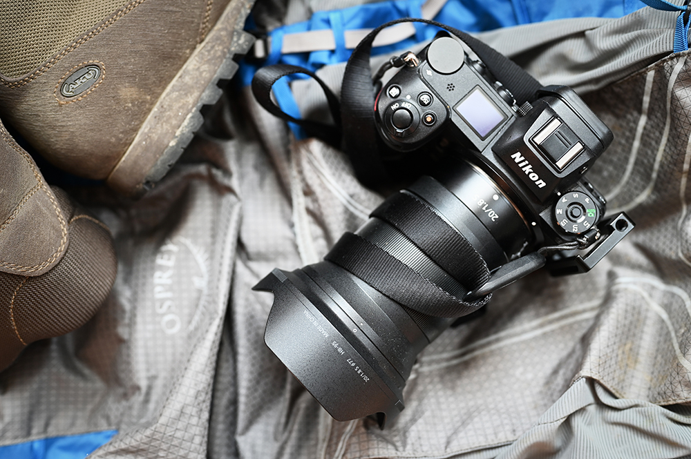
Coping with weight – one lens or three
I’m carrying things in an ultra-lightweight Osprey pack – the Exos Pro 55, to be precise, which is extremely comfortable and almost unbelievably lightweight considering it’s a large pack with a 55 litre capacity, a frame and very good back support, yet it weighs in at just just a smidgin over 1kg (that’s less than many small day packs). In general I’d aim to carry somewhere between 8kg and 12kg on my back, depending on the trail and time of year, including the weight of the pack itself and one litre of water. I carry a small water filter made by LifeStraw, so I can refill from springs and streams during the day – unless it’s a limestone area like Croatia or Montenegro for example, in which case I’d need to carry more water.
Camera gear is in addition to that weight. Along with a Nikon mirrorless body (Z6) I’ve brought three fast primes with me – a Nikon S series 20mm f1.8, 50mm f1.8 and 85mm f1.8. These focal lengths cover most things I’ll want to photograph on a trip like this, from landscapes to portraits, with the obvious exception of wildlife. While it’s perhaps not the most obvious combination for landscapes and travel, I love using primes, and they also come into their own in low light or indoors – such as a Corsican couple who make cheese in the high pastures above Bourg-Saint-Pierre, who I photograph in their cottage and dark stone cellar (a clever use of time while sheltering from a brief downpour, arranged thanks to Mélanie). I’m carrying these in a MindShift holster and a couple of ThinkTank pouches. I’m not carrying a tripod this time, a compromise to save weight and because the weather forecast includes a couple of stormy days – in which case it can feel a bit like carrying a big lightning conductor on your back but I have a Platypod Ultra thrown in the top of my pack just in case. The thought process behind deciding how best to carry camera gear on an extended hiking trip – in a dedicated camera backpack, in a holster and so on – is something I’ll talk about more in the next article in this series.


Early morning light on the Great St Bernard Pass – Lake below the Fenêtre de Durand – Edelweiss near Lac de Mauvoisin – © Rudolf Abraham
Dam, lakes and vultures
It’s a 1000m descent from the Col des Otanes to Mauvoisin, passing a cluster of shallow tarns, where rain-streaked skies and billowing clouds obscure the views of the valley below, but lend extra drama to some black and white conversions. We spend the night at Mauvoisin, and the following morning head up a trail beside the enormous concrete face of the Mauvoisin dam – at 250m high it’s the second highest in Switzerland, and still among the tallest in the world. At the top we are met by René Maret, former mechanic at the Fionnay Hydroelectric Centre, who leads us on a tour inside the wall of the dam, down long concrete halls and tunnels and past huge machinery, emerging from a bunker-like entrance on the far side. Beyond the dam, we follow a 4×4 track above the elongated, vivid turquoise sweep of the Lac de Mauvoisin, cloud shadows drifting across its surface, waterfalls tumbling down below dark grey cliffs on either side, and a bearded vulture gliding above the shoreline further ahead. Valais is one of three cantons in Switzerland where the bearded vulture can be seen – a magnificent bird, with a wingspan of 280cm or more. But it’s heading in the opposite direction to the trail we want for the Col de Tsofeirë, so I ‘make do’ with a cluster of edelweiss I find beside the trail.
After passing the abandoned shepherd’s huts at Giétro – a beautiful example of dry stone construction – we continue for another couple of hours to the smaller of the two lakes which lie below the col, and stop for a memorably elaborate picnic lunch which includes a panoply of delicious Swiss cheeses, not to mention a fair amount of Swiss chocolate. Oh hardship. The trail down from the Col de Tsofeirë is steep, with an exposed section descending over loose, splintered rock – the sort of place where I tend to pack my camera away and focus on where I’m putting my feet. Probably a good thing there wasn’t any wine with that lunch (in case you’re wondering, there never is – though locally brewed beers in a mountain hut in the evening are quite a different matter).
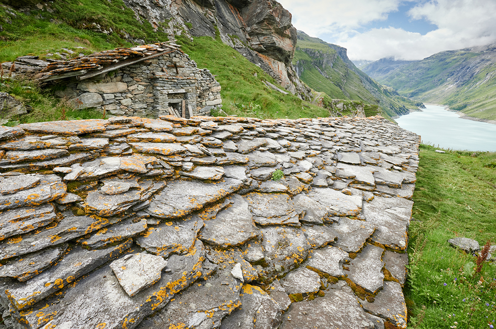
Abandoned shepherd’s hut at Giétro, above Lac de Mauvoisin – © Rudolf Abraham
Ready for the unexpected
I’m erring on the side of caution with the hiking gear I’m carrying on this trip – a bit more cold weather clothing than I’d usually bring at this time of year, including a heavier insulated jacket, an extra pair of warm gloves and so on, all meaning, more weight to carry. I make a point of trying not to underestimate mountain weather, which can be fickle in the extreme. I learnt that one the hard way long ago. And it’s good that I did – halfway through the trip it snowed on higher areas during the night, making for a chilly early morning start from Cabane de Chanrion, and leaving ice on a few passes.
However in the end this also made for one of the most memorable parts of the Tour des Combins. Heading up to the 2,797m Fenêtre de Durand on the Swiss-Italian border, frost coats the grassy path along with the now familiar blaze of wild flowers, and the morning sun strikes the snow-caked ramparts of Mont Avril, below masses of wonderfully pillowy clouds. We stop below the dark, shattered slopes of Mont Gelé, looking down across an unbelievably vivid blue lake to the Vall d’Aosta. Then we shoulder our packs, and begin the long descent into Italy – it will be another four and a half hours before we reach the next mountain hut.


Lac de Chanrion and Mont Gelé, viewed from Cabane de Chanrion – Hiker framed by rock on the trail to the Fenêtre de Durand – Evening cloud on Mont Gelé – © Rudolf Abraham
Early the following morning, the start of the day is brutal – a steep, relentless 300m climb leading strait up from beside Rifugio Champillon. But the Col de Champillon when we reach it, makes up for it all with amazing views back to Mt Gelé, and a nicely placed rock with a hole in it beside the trail, perfect for framing approaching hikers. It’s always fortunate when you’re in the company of people who accept being asked to repeatedly hike up and down the same stretch of trail until you get the shot you wanted. The way down the other side feels long – and it is: 900m descent to the Menouve stream, where we crash out on a patch of grass, kick off our boots and enjoy a well-earned lunch, eating the last of the cheeses and other food we’ve been carrying.
The final night is spent on the trail at the Great Saint Bernard Pass, staying at the Hospice (founded in the 11th century) and eating in the refectory. This is the only point on the entire trail which could be called busy – there’s a road over the pass after all, and it’s on the Via Francigena, the ancient pilgrim’s route to Rome. Not to mention roadside stalls with an armada of Saint Bernard soft toys, in a mind-boggling array of sizes, fluffyness and price tags – if you’re a parent, good luck getting past this one without feeling an unshakable obligation to buy one.


Early morning light on the Pain du Sucre and other peaks above the Great St Bernard Pass – Lake and hiker on the descent from the Col des Otanes – © Rudolf Abraham
In Napoleon’s footsteps
In the morning I quietly slip out of the dormitory soon after dawn, to catch the first blaze of light on the lopsided fang of the Pain du Sucre and other spiky peaks above the Lac du Grand Saint-Bernard. Then after a quick breakfast there’s one more pass to cross – this is the 2714m Pas des Chevaux, traversed by Napoleon and his Reserve Army in 1800 on his way to Genoa. If you’re thinking of Jacques-Louis David’s famous series of equestrian portraits of Napoleon crossing the Alps, bear in mind that the First Consul would have been riding a donkey at this point, not the noble steed depicted. The reason becomes apparent fairly quickly as we begin our descent – a narrow, friable path with a wall of rock on one side and a sizeable drop on the other.
After the exposed sections it’s a gradual descent towards Burg St Pierre, passed quickly except for some herds of cattle to bypass. And then the rain, which has been following stealthily, finally closes in, bringing whitewashed skies and increasingly slippery paths. Thoughts of photography are sidelined and, heads down, we plough on ahead to the village.
My favourite moment…
It’s almost always ridiculously hard to pick a favourite moment, one single view, experience, memory from a long-distance hike like this – should I say the mind-bogglingly beautiful scenery, the people, the immensity of rock and sky, the sweep of an eagle or the flash of a dragonfly’s wings, the silence, the fleeting magic of light and shadow? More often than not, it’s impossible to untangle one of these from another. But if I had to pick one defining moment from the Tour des Combins, and since I’m writing here about both hiking and photography, then it would probably have to be that early morning hike up to the Fenêtre de Durand, below a snow-encrusted Mont Avril, before gazing down into a sun-drenched Italy. It was just one of those moments when the light, the view, and the right choice of lens all came together.
And favourite photograph…
Mont Avril with late July snowfall, seen from the trail to the Fenêtre de Durand – © Rudolf Abraham
Looking back over the images edited from the Tour des Combins, one of my favourite is also one of the most fleeting and least planned. We were dropping down to cross the Bagnes steam (there’s always a feeling of disappointment as you descend, knowing that the ascent on the opposite side of the valley is becoming correspondingly longer!), when we traversed an area of shadow, and I looked up again to see the face of Mont Avril in beautiful light and framed by cottonwool clouds. Sophie and Joe had just walked over to the edge of a slight rise, to admire the view (possibly of their own accord, possibly because I asked them to, I can’t remember), I had an 85/1.8 attached, and there it was – I just had to crouch down lower to enhance the angle of view.
Next adventure: The Juliana Trail in Slovenia in all seasons
All images © Rudolf Abraham
Photographer https://www.rudolfabraham.com
Find out about visiting Switzerland
